Information about heights of various sites.
The Western Manhood is very low lying and large areas are in a flood plain. For that reason the actual heights of these sites is critical and is measured in meters above a well defined reference point called Above Ordnance Datum (A.O.D.) Think of AOD as very being roughly sea level for simplicity’s sake.
The table below shows all the planning applications for the Western Manhood Peninsula of ten or more dwellings that have been lodged with CDC in the last ten years. Some of these are already built, some are approved but not yet built and some are pending the CDC decision or awaiting the outcome of an appeal by the developer.
They are sorted by the minimum heights of the site. The “Application No.” and the ” Reference” are hyperlinked so will take you directly to the respective planniong portal or the source of this data – typically flood risk assessments commissioned by the developer.
| Heights of sites AOD | ||||||
|---|---|---|---|---|---|---|
| Qty | Applic. No. | Where | Min | Max | Reference | Column1 |
| 308 | 23/01967/FULEIA | Medmerry Park | 1.6 | 4.2 | Herrington | Lodge floore 4.44 AOD |
| 100 | 20/03125/OUT | Barratts, Clappers Lane | 2.7 | 5.2 | CEP letter | |
| 110 | 14/01806/out | Wates Clappers Lane | 3.13 | 5.58 | 4.8 floor levels | |
| 30 | 20/02236/OUT | Earnley Concourse | 3.72 | 5.54 | RSK | |
| 50 | 12/02461/ful | Beech Avenue | 3.86 | 4.67 | Wates FRA | |
| 85 | 18/00753/out | South Downs Holiday Park | 4.12 | 5.12 | SWP FRA | |
| 17 | 12/03749/ful | Piggery Hall Lane | 4.18 | 5 | Stuart Michael FRA | Fllor levels 5.85 |
| 26 | 16/01020/ful | Stocks Lane | 4.6 | 5 | Mott MacDonald | |
| 45 | 22/02235/OUT | Barratts 45,Church Rd. | 4.68 | 5.96 | Pell Frishmann | |
| 285 | 22/02214/FULEIA | Barratts 285, Church Road | 4.68 | 5.96 | Pell Frischmann | |
| 65 | 21/01376/OUT | Emeray,Bracklesham Lane | 4.8 | 5.3 | Roberst Clark Assoc letter | |
| 50 | 13/03286/ful | Chaucer Drive | 4.83 | 5.08 | MJA Consulting | |
| 70 | 20/02491/OUT | Welbeck,Church Road | 4.88 | 5.36 | Pell Frishmann | 4.43 living. 4.77 sleeping |
| 14 | 23/00067/FUL | Russels Nurseries | 5.6 | 6.2 | CGS Civils | |
| 150 | 21/01830/OUT | Gladman1,Birdham Main Rd. | 5.83 | 6.9 | ||
| 150 | 23/1497/OUT | Gladman2,Birdham Main Rd | 5.83 | 6.9 | ||
A graphic often provides digestible information as opposed to dry data so the chart below takes the data from the above table and presents it as a bar chart. The lowest sites are at the left and the highest at the right.
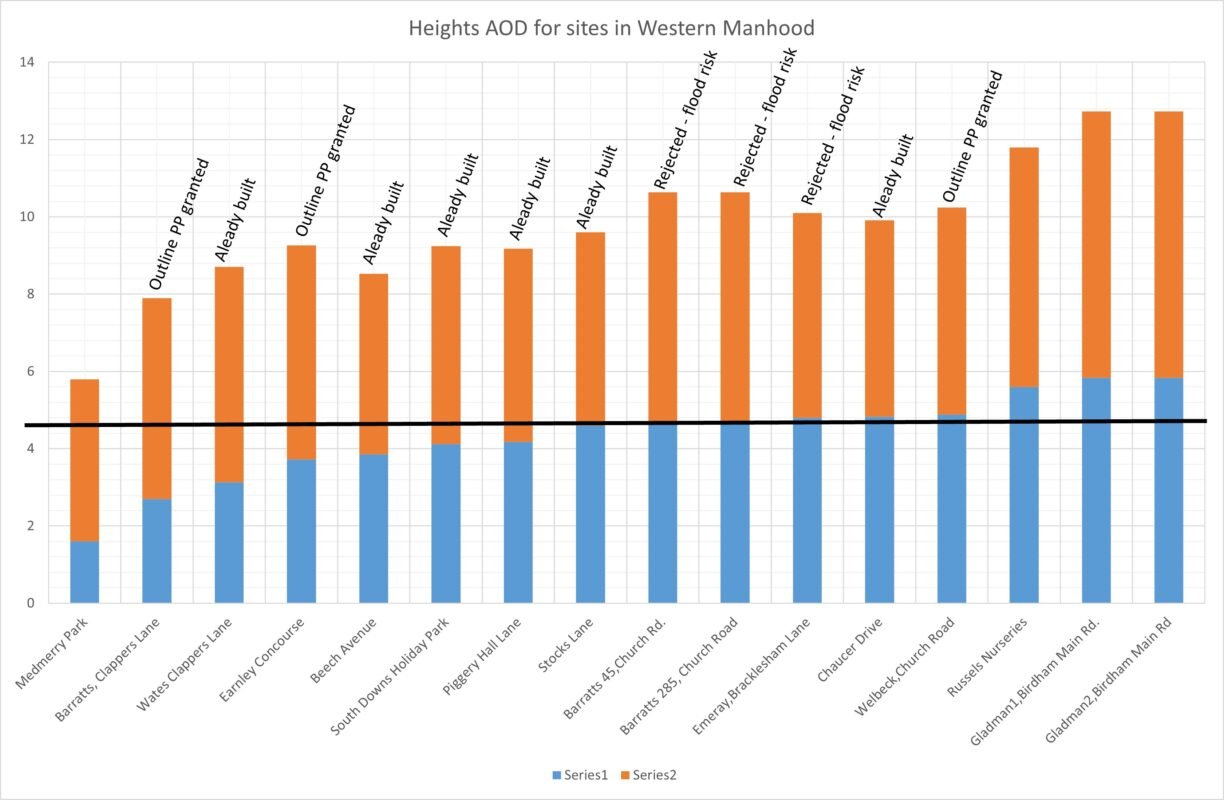
The solid black line is the minimum height of the two Barratts sites in Church Road East Wittering where CDC planning officers and the planning committee rejected the applications. Of the ten reasons for rejection, flood risk was paramount. The bars for these sites are marked “Rejected – flood risk”
So applying the same logic all bars/sites to the left of these two are risky but nothing can be done about those already built but there are three sites where outline planning permission has been granted ….